

Boucle régionale entre Sarthe et Loir (regional loop)
Didacticiel des cartes
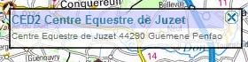
Maps tutorialclick on icon (waypoint) The click on icon shows a popup that gives you details and information about different accommodations and equestrian centres.
Click on the departmental route
Click once on the departmental route to access to a button. Click on the button to view the page of the corresponding path.
|
||
Personnes concernées:
Cavaliers
Distance:
112 kms
Duration:
4 jours
Percentage of paths:
60 %
Length of urban area:
3.5 kms
1 kms
2 kms
0.5 kms
Car park address at starting point:
aire d'accueil équestre de parigné le Polin
Other car parks:
Chateau l'hermitage reception area.
Flée village, communal car park near the castel.
Description:
This trail joins several different trails (Parigné le Polin , Bercé , Coteaux du Loir) and can be travelled in several stages or split.
This trail is not specifically marked for riders, so please make sure to have the necessary maps. You can print some of them here. Using the interface, select the scale and take a screenshot of the parts you wish to print.
Accommodations on the itinerary:
Dangerous areas, restrictions:
crossing the D307 road, place known as "L'arche"
crossing D138 road, after Ecommoy
crossing D138 road, place known as "Laillé"
crossing D307 crossroads "les trois maillets"
Downloads: